
Find it with GPS!
This lesson explores the technology that makes GPS possible and takes a look at global variations. Students work in teams to brainstorm recommendations for applying GPS technology to meet the needs of a global society.
- Learn about global positioning systems.
- Learn about engineering design.
- Learn how engineering can help solve society’s challenges.
- Learn about teamwork and problem solving.
Age Levels: 8-18
Build Materials (For each team)
Required Materials
- Student Worksheets
- Rope or string
- At least one handheld GPS system (phone or separate device)
Design Challenge

You are a team of engineers who have been given the challenge of solving a problem the world faces through the use of GPS. First, you will compare measuring the distance between two spots in your school yard using both a GPS system (either handheld, or one embedded in a phone) and a traditional measurement, using a rope or string.
Then, you will brainstorm within your group to identify three problems, and then determine which of the three has the greatest impact on society. You’ll develop a proposal to present to your class and then each team will reflect and consider the best new application of GPS. You’ll have to consider whether potential errors or even sabotage of the GPS system would cause more problems than your application would solve.
Criteria
- Compare the distance between 2 spots.
- Propose 3 problems.
Constraints
- Use only the materials provided.
- Break class into teams of 2-3.
- Hand out the Find it with GPS worksheet, as well as some sheets of paper for sketching designs.
- Discuss the topics in the Background Concepts Section. Share the PBS interactive website (www.pbs.org/wgbh/nova/longitude/gps.html) that illustrates the GPS technology and explains trilateration.
- Review the Engineering Design Process, Design Challenge, Criteria, Constraints and Materials.
- Provide each team with their materials.
- Explain that students must complete the challenge in 3 phases:
● Investigative Phase: Using a GPS system (either handheld, or one embedded in a phone) and traditional measurement, using a rope or string:
○ Mark two positions in your school yard with a flag or small stick.
○ Mark the original location with a GPS, walk to the second location and mark the second spot.
○ Determine the distance between the two locations based on the location information provided by the GPS.
○ Measure the distance using string or rope.
○ Answer questions in the student worksheets.
● Brainstorming Phase: Meet as a team to brainstorm new applications of GPS that would solve a problem faced by humans, animals, or the environment. Be creative and think of large or small problems that people deal with either on an individual or global basis. Then, identify three problems you think could be addressed using GPS.
● Presentation Phase: As a team, agree which of the three problems you identified would result in the greatest benefit to the world. Answer the following questions about the new application, in preparation for your class presentation. You may want to draw a diagram to illustrate your idea, create a poster or PowerPoint presentation, or use other materials to demonstrate your idea for the class.
○ Briefly describe the problem your team decided to address: How does the application of GPS aid in solving this challenge?
○ What would happen to your solution, if for some reason the satellite system stopped working temporarily? Permanently? Would there be any bad effects?
○ How many people or animals do you estimate would be impacted by your solution?
○ Who should pay to implement your idea? A government, a business, individuals, a university? Why?
○ How long do you think it would take engineers to implement your idea? Be specific and consider research, testing, manufacturing.
○ Are there any ethical considerations that might make others not approve your idea? - Announce the amount of time they have to complete the 3 phases (2-3 hours recommended).
- Students complete the phases.
- Teams make their presentation to the class
- As a class, discuss the student reflection questions.
- For more content on the topic, see the “Digging Deeper” section.
Student Reflection (engineering notebook)
- What was the best new application of GPS you heard during your class presentations? Why?
- What steps do you think you would need to take to try and actually make this application a reality?
- Are there any ethical or legal issues you think you would need to address if you actually implemented your idea? For example, if you added GPS to a product that already exists, such as a ski design, who would benefit from the sale of the new GPS ski? You or the original ski designer, or both? Why?
- How important an invention do you think GPS is? Why?
- Can you think of other engineering achievements that have impacted the world? Which do you think has had the most positive impact on people? On the environment? On animals?
Time Modification
The lesson can be done in as little as 1 class period for older students. However, to help students from feeling rushed and to ensure student success (especially for younger students), split the lesson into two periods giving students more time to brainstorm, test ideas and finalize their design. Conduct the testing and debrief in the next class period.
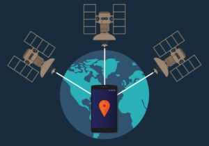
What is the Global Positioning System?
The Global Positioning System (GPS) is a constellation of navigation satellites that orbit the Earth at an altitude of about 12,000 miles (20,000 kilometers). At this altitude, the satellites complete two orbits in a little less than a day. Though originally designed by the U.S. Department of Defense for military applications, the federal government made the system available for civilian uses and lifted security measures designed to restrict accuracy to 10 meters. The optimal constellation consists of 21 satellites with 3 operational “spares.” As the image to the right indicates, the orbits of GPS satellites are inclined to the Earth’s equator by about 55º. The system is designed to ensure that at least four satellites are visible at least 15° above the horizon at any given time, anywhere in the world.
GLONASS and GALILEO
GALILEO is the European global navigation satellite system that is currently under development. Currently users in Europe have had no alternative other than to use American GPS or Russian GLONASS satellite signals. This new system will be under civilian control, and promises to be interoperable with GPS and GLONASS.
Determining Positions
Positions are obtained from GPS by determining distances to the visible satellites in a process known as trilateration. A PBS website illustrates this principle at www.pbs.org/wgbh/nova/longitude/gps.html. The time of the signal transmission at the satellite is compared to the time of reception at the receiver. The difference of between the two indicates how long it took for the signal to travel from the satellite to the receiver. By multiplying the travel time by the speed of light, we determine the distance to the satellite. As the image to the right shows, by repeating this process on three satellites, you have an area where all three overlap which is a two-dimensional position on the Earth. A fourth satellite is needed to determine the third dimension — height. The more satellites that are visible, the more accurate is the resulting position. There are sources of error though, including clock errors, atmospheric delays, signals reflecting off of objects on the surface of the Earth, and degradation of the satellite signal.
A Closer Look at the Science and Math
The Global Positioning System allows a GPS receiver to determine its position by using the formula: (Velocity x Time = Distance).
For a common example, consider the question if a bicycle is travelling at 15 miles or kilometers an hour for three hours, how far would it have travelled? In this case, the answer is: Velocity (15 mph) x Time (3 hours) = Distance (45 miles)
For GPS we are not measuring the speed of a bicycle, but rather the speed at which a radio signal travels which is roughly 186,000 miles per second. The bigger challenge is measuring the travel time. If one of the satellites is overhead the travel time would be very short, about 0.06 seconds. So the system relies on very precise clocks to be able to differentiate the time it takes one satellite to send a signal to a GPS device.
The signal is really called “Pseudo Random Code” (PRC) which is basically a complex sequence of “on” and “off” digital pulses. The GPS satellites continuously transmit these PRCs at specific, planned times. The GPS device then has to measure the exact instant when the PRC arrives and calculate the difference between the receiving time and the time the signal left the satellite in order to determine the “time.” The times have to be very accurate because a clock error in the receiver of even a few nanoseconds would result in a positioning error of several hundred meters.
So, for a GPS formula example: Velocity (186,000 miles per second) x Time (.065 seconds or 650,000 nanoseconds) = Distance (12090 miles)
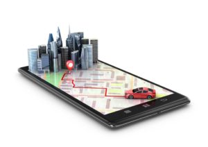
GPS Applications
Civilian Usage
There are many GPS applications for civilian use. Many use GPS systems to keep track of their location and destination when hiking or driving. In many parts of the world, GPS is improving bus and taxi service and safety. Having the ability to track cabs or busses with a GPS system, dispatchers can ensure that their companies’ drivers reach passengers quickly and thus do more business per day.
In Australia, GPS is making train travel more predictable. GPS technology keeps on-board and waiting passengers informed of a train’s location and destination arrival times. In the United Kingdom, the 1995 British Olympic Sailing Trials at Weymouth Bay and Portland Harbour represented the first-ever use of GPS technology in sailing race course mapping. Traditional course setting has been difficult and inconsistent as weather conditions have often forced course layers to make changes in courses. In doing so, the course setters can inadvertently alter the intended length of a course. Using handheld GPS receivers, however, the Royal Yachting Association’s organizers of the British Olympic Trials were able to collect positioning data and thus ensure that the qualifying events maintained the same, accurate course lengths, no matter what the existing weather conditions. This way, the trial courses would meet the standards upheld by the organizers of the Olympic Games.
Tracking glaciers, ice flows and icebergs with GPS prevent damage and loss of life, and have applications wherever humans travel or live in Arctic regions. Notably in Iceland, GPS is used to track a recent glacier meltdown caused by a volcanic eruption beneath the glacier’s ice sheet. The data collected is helping to predict the movement of the ice and flood waters. By allowing effective safety measures to be put in place, planning with this information will save lives in the future.
Military Applications
GPS has become important for nearly all military operations and weapons systems. It allows troops to advance in sandstorms, and helps identify the location of individual soldiers.
New Applications
Engineers and scientists are always coming up with new applications for established technologies such as GPS! For example, during disease outbreaks, the GPS system was used to create immediate mapping of cases of the flu as they were reported.
- Constraints: Limitations with material, time, size of team, etc.
- Criteria: Conditions that the design must satisfy like its overall size, etc.
- Engineers: Inventors and problem-solvers of the world. Twenty-five major specialties are recognized in engineering (see infographic).
- Engineering Design Process: Process engineers use to solve problems.
- Engineering Habits of Mind (EHM): Six unique ways that engineers think.
- GPS: Global Positioning System. A constellation of navigation satellites that orbit the Earth at an altitude of about 12,000 miles (20,000 kilometers).
- Iteration: Test & redesign is one iteration. Repeat (multiple iterations).
- Prototype: A working model of the solution to be tested.
Internet Connections
- Global Positioning System
- European Space Administration – Galileo System
- GPS Application Examples
- Trimble GPS Tutorial
Recommended Reading
- Fun with GPS (ISBN: 1589480872)
- GPS For Dummies (ISBN: 0470156236)
- Global Positioning System: Theory and Practice (ISBN: 3211835342)
Writing Activity
Write an essay or a paragraph exploring whether you think it is an appropriate or inappropriate use of GPS technology for police to track the whereabouts of a suspect of a crime? Presume the suspect has not been arrested nor convicted of this or any crime, and the police would attach a GPS system to the undercarriage of the suspect’s car without their notification.
Alignment to Curriculum Frameworks
Note: Lesson plans in this series are aligned to one or more of the following sets of standards:
- U.S. Science Education Standards (http://www.nap.edu/catalog.php?record_id=4962)
- U.S. Next Generation Science Standards (http://www.nextgenscience.org/)
- International Technology Education Association’s Standards for Technological Literacy (http://www.iteea.org/TAA/PDFs/xstnd.pdf)
- U.S. National Council of Teachers of Mathematics’ Principles and Standards for School Mathematics (http://www.nctm.org/standards/content.aspx?id=16909)
- U.S. Common Core State Standards for Mathematics (http://www.corestandards.org/Math)
- Computer Science Teachers Association K-12 Computer Science Standards (http://csta.acm.org/Curriculum/sub/K12Standards.html)
National Science Education Standards Grades K-4 (ages 4-9)
CONTENT STANDARD A: Science as Inquiry
As a result of activities, all students should develop
- Abilities necessary to do scientific inquiry
- Understanding about scientific inquiry
CONTENT STANDARD B: Physical Science
As a result of the activities, all students should develop an understanding of
- Position and motion of objects
CONTENT STANDARD D: Earth and Space Science
As a result of their activities, all students should develop an understanding of
- Objects in the sky
CONTENT STANDARD E: Science and Technology
As a result of activities, all students should develop
- Abilities of technological design
- Understanding about science and technology
CONTENT STANDARD F: Science in Personal and Social Perspectives
As a result of activities, all students should develop understanding of
- Science and technology in local challenges
National Science Education Standards Grades 5-8 (ages 10-14)
CONTENT STANDARD A: Science as Inquiry
As a result of activities, all students should develop
- Abilities necessary to do scientific inquiry
- Understandings about scientific inquiry
CONTENT STANDARD B: Physical Science
As a result of their activities, all students should develop an understanding of
- Motions and forces
CONTENT STANDARD E: Science and Technology
As a result of activities in grades 5-8, all students should develop
- Abilities of technological design
- Understandings about science and technology
CONTENT STANDARD F: Science in Personal and Social Perspectives
As a result of activities, all students should develop understanding of
- Risks and benefits
- Science and technology in society
National Science Education Standards Grades 5-8 (ages 10-14)
CONTENT STANDARD G: History and Nature of Science
As a result of activities, all students should develop understanding of
- History of science
National Science Education Standards Grades 9-12 (ages 14-18)
CONTENT STANDARD A: Science as Inquiry
As a result of activities, all students should develop
- Abilities necessary to do scientific inquiry
- Understandings about scientific inquiry
CONTENT STANDARD E: Science and Technology
As a result of activities, all students should develop
- Abilities of technological design
- Understandings about science and technology
CONTENT STANDARD F: Science in Personal and Social Perspectives
As a result of activities, all students should develop understanding of
- Science and technology in local, national, and global challenges
CONTENT STANDARD G: History and Nature of Science
As a result of activities, all students should develop understanding of
- Historical perspectives
Next Generation Science Standards – Grades 2-5 (Ages 7-11)
Engineering Design
Students who demonstrate understanding can:
- 3-5-ETS1-1.Define a simple design problem reflecting a need or a want that includes specified criteria for success and constraints on materials, time, or cost.
- 3-5-ETS1-2.Generate and compare multiple possible solutions to a problem based on how well each is likely to meet the criteria and constraints of the problem.
Next Generation Science Standards – Grades 6-8 (Ages 11-14)
Engineering Design
Students who demonstrate understanding can:
- MS-ETS1-2 Evaluate competing design solutions using a systematic process to determine how well they meet the criteria and constraints of the problem.
Standards for Technological Literacy – All Ages
The Nature of Technology
- Standard 1: Students will develop an understanding of the characteristics and scope of technology.
- Standard 2: Students will develop an understanding of the core concepts of technology.
- Standard 3: Students will develop an understanding of the relationships among technologies and the connections between technology and other fields of study.
Standards for Technological Literacy – All Ages
Technology and Society
- Standard 4: Students will develop an understanding of the cultural, social, economic, and political effects of technology.
- Standard 5: Students will develop an understanding of the effects of technology on the environment.
- Standard 6: Students will develop an understanding of the role of society in the development and use of technology.
- Standard 7: Students will develop an understanding of the influence of technology on history.
Design
- Standard 9: Students will develop an understanding of engineering design.
Abilities for a Technological World
- Standard 13: Students will develop abilities to assess the impact of products and systems.
The Designed World
- Standard 17: Students will develop an understanding of and be able to select and use information and communication technologies.

 Industrial Engineering
 Computer Engineering
Applying Technology to Solve Problems
You are a team of engineers who have been given the challenge of solving a problem the world faces through the use of GPS. You will brainstorm within your group to identify three challenges, and then determine which of the three has the greatest impact on society. These might solve a human problem, and animal problem, or an environmental problem.
You’ll develop a proposal to present to your class and then each team will reflect and consider the best new application of GPS. You’ll have to consider whether potential errors or even sabotage of the GPS system would cause more problems than your application would solve. For example, some are considering using GPS to keep track of criminals on early release programs from prison. If we know that GPS is sometimes unreliable in the middle of large buildings, would this be a safe application?
Research/Preparation Phase
- Review the various Student Reference Sheets to learn all about GPS.
- Visit the PBS interactive website (www.pbs.org/wgbh/nova/longitude/gps.html) that illustrates the GPS technology and explains trilateration. If internet access is not available in your school, your teacher may provide the activity to you on a local computer.
Investigation Phase
- Demonstrate the GPS system using a handheld GPS device, or phone equipped with GPS technology. Here’s how:
- Mark two positions in your school yard with a flag or small stick.
- Mark the original location with your GPS, walk to the second location and mark the second spot.
- Determine the distance between the two locations based on the location information provided by the GPS. Incorporate any notes in the box below:
|
|
- Now…try measuring the distance using string or rope.
- Answer the following questions — be sure to discuss as a group!
- Did you find a difference between the physical measurements you made using a string or rope and the GPS result? If so, why do you think there was a difference?
- Which method did you think was easier? Why?
- Which method would be easier if you were measuring the distance between two schools across town? Why?
Brainstorming as a Team
-
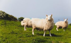
artursz-bigstock.com Meet as a team to brainstorm new applications of GPS that would solve a problem faced by humans, animals, or the environment. Be creative and think of large or small problems that people deal with either on an individual or global basis. As an example, sheepherders may need to identify the location of their animals if a large storm was approaching. They frequently roam in remote areas. Attaching a GPS device to the animals would allow tracking of the location of the animals in an emergency situation.
- In the box below indicate the three problems you think could be addressed using GPS and answer the related questions.
| Problem Description | How would GPS help? | How many people/animals are impacted by this challenge? | Who would pay for the costs associated with this solution? | What products would have to be adapted, if any, as part of this application |
| 1.
|
||||
| 2.
|
||||
| 3.
|
Presentation Preparation
- As a team, agree which of the three problems you identified would result in the greatest benefit to the world.
- Answer the following questions about the new application, in preparation for your class presentation. You may want to draw a diagram to illustrate your idea, create a poster or PowerPoint presentation, or use other materials to demonstrate your idea for the class.
Briefly describe the problem your team decided to address:
How does the application of GPS aid in solving this challenge?
What would happen to your solution, if for some reason the satellite system stopped working temporarily? Permanently? Would there be any bad effects?
How many people or animals do you estimate would be impacted by your solution?
Who should pay to implement your idea? A government, a business, individuals, a university? Why?
How long do you think it would take engineers to implement your idea? Be specific and consider research, testing, manufacturing.
Are there any ethical considerations that might make others not approve your idea?
Presentation
- Present your GPS application recommendation to the class and pay attention to the recommendations of the other teams in your classroom.
Evaluation
Complete the evaluation questions below:
- What was the best new application of GPS you heard during your class presentations? Why?
- What steps do you think you would need to take to try and actually make this application a reality?
- Are there any ethical or legal issues you think you would need to address if you actually implemented your idea? For example, if you added GPS to a product that already exists, such as a ski design, who would benefit from the sale of the new GPS ski? You or the original ski designer, or both? Why?
- How important an invention do you think GPS is? Why?
- Can you think of other engineering achievements that have impacted the world? Which do you think has had the most positive impact on people? On the environment? On animals?
Downloadable Student Certificate of Completion